
Contents
Wind Project Site
(login for email address)
Details
Description
Sunrise Wind will be composed of 95 Siemens Gamesa turbines with an installed capacity of approximately 924 MW. The potential capacity of the wind farm will be enough to power nearly 600,000 homes. Sunrise Wind is expected to be operating in 2027. Sunrise Wind will support approximately 800 jobs through the project’s development, construction, and operation.
Location
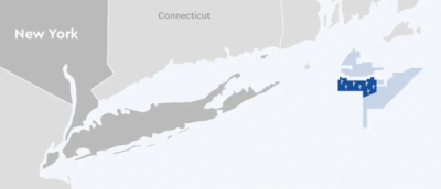
The Sunrise Wind Lease Area covers approximately 86,823 acres and is located in federal waters approximately 30.4 km south of Martha’s Vineyard, Massachusetts and approximately 48.1 km east of Montauk, New York, and 26.8 km from Block Island, Rhode Island. The planned interconnection point is the Holbrook and West-Bus substation in the town of Brookhaven within the Long Island Power Authority’s (LIPA) service territory. The offshore export cables would be buried below the seabed in federal and New York State waters.
Project Timeline
- 2027: Projected Commissioning date
- 2024, July: Construction began
- 2024, June: Construction and Operations Plan approved
- 2023, February: Public Consultation Window on the Draft Environmental Impact Statement
- 2022, December: BOEM Announced Availability of the Draft Environmental Impact Statement
- 2022, November: New York State PSC Approval
- 2022, June: NPS Permit Application Deemed Complete
- 2021, October: Geophysical Surveys and Site Investigations
- 2021, May: Construction and Operations Plan Submitted
- 2021, April: Geophysical Survey along Export Cable
- 2021, March: Issuance of Commercial Lease of Submerged Lands for Renewable Energy Development on the OCS
- 2020, February-March: Geophysical Surveys and Site Investigations
- 2019, July: Offtake Conditionality Secured
- 2013, July: Site Exclusivity
Licensing Information
The Sunrise Wind project pursued comprehensive licensing and permitting across federal and state agencies throughout 2022 and 2023. In 2022, the project filed multiple permits, including the Environmental Management and Construction Plan with the New York State Department of Public Service, Clean Water Act Section 404 and Rivers and Harbors Act permits with the U.S. Army Corps of Engineers, and an Outer Continental Shelf Air Permit with the U.S. EPA. The project obtained the National Park Service Right-of-Way and Special Use Permits and filed utility work permits with the New York State Department of Transportation. Throughout 2022, the project completed consultations and received certifications from multiple New York State agencies. In 2023, the project secured the NOAA Incidental Take Authorization in February and the U.S. Fish and Wildlife Service Endangered Species Act Consultation Package Conclusion in June, advancing its regulatory compliance process. On June 6, 2023, extensions were approved for the NEPA, COP, Section 106, MMPA (NOAANMFS), Sections 10/404/408 (USACE), NPS Permit, Clean Water Act Section 402 (EPA), and OCS Air Permit (EPA). Further extensions for COP, NPS, Section 10/404, Section 408, OCS Air Permit, and NPDES completion dates were granted on February 2, 2024. As of July 2024, Sunrise Wind has officially completed federal environmental review and permitting through the Permitting Council’s FAST-41 program.
Environmental Papers and Reports
- Sunrise Wind Pile Driving Monitoring Plan (OCS-DC Jacket Foundation) Sunrise Wind 2025
- Sunrise Wind Pile Driving Monitoring Plan (WTG Monopile Foundation) Sunrise Wind 2025
- Assessing highly migratory species 2023 Kneebone et al. 2024
- 2023 Sunrise Wind Export Cable Acoustic Telemetry Study Peterson et al. 2024
- Fisheries Compensation Agreements & Offshore Wind McCrorey and Wyman 2024
- Annual Monitoring Survey of the Sunrise Wind Farm Lease Area - 2023 Annual Report O'Hara et al. 2023
- Final Environmental Impact Statement for the Sunrise Wind Project Bureau of Ocean Energy Management (BOEM) 2023
- Assessing highly migratory species 2022 Kneebone and Kim 2023
- Annual Monitoring Survey of the Sunrise Wind Farm Lease Area - 2022 Annual Report O'Hara et al. 2022
- Sunrise Wind Draft Environmental Impact Statement (DEIS) Bureau of Ocean Energy Management (BOEM) 2022
- 2022 Annual Report: Sunrise Wind Telemetry Project Sclafani et al. 2022
- Sunrise Wind Construction and Operations Plan Stantec Consulting 2022
- Protected Species Observer Technical Report for the Ørsted New England IHA, BOEM Lease Areas OCS-A 0486, OCS-A 0487, and OCS-A 0500; 2019–2020 Smultea et al. 2020
NOAA Fisheries has developed Offshore Wind Lease Reports that summarize previous fishing activity within each offshore wind lease area along the U.S. Atlantic Coast. View Descriptions of Selected Fishery Landings and Estimates of Vessel Revenue from Areas: A Planning-level Assessment and Descriptions of Selected Fishery Landings and Estimates of Recreational Party and Charter Vessel Revenue from Areas: A Planning-level Assessment for Sunrise Wind (OCS-A-0487) here.
Environmental Monitoring: Sunrise Wind
| ID | Phase | Stressor & Receptor | Design and Methods | Results | Publications | Data |
|---|---|---|---|---|---|---|
| 2075049 | Baseline | Bats | Bat Assessment
The description of the affected environment and assessment of potential impacts to bats were developed by reviewing current public data sources related to bats, including published scientific literature and correspondence and consultation with federal and state agencies. Acoustic and vessel-based surveys were conducted within the Sunrise Wind project area. |
Complete Bats are generally expected to occur in the Sunrise Wind outer continental shelf only during migratory periods, particularly in August and September. Available information suggests that activity is likely to increase with proximity to shore. | Stantec Consulting 2022 | No data publicly available. |
| 2075050 | Baseline | Birds | Avian Assessment Species that may occur within the Sunrise Wind project area were based on observations made during the Bay State Wind and MassCEC avian surveys as well as results of NYSERDA 2016-2019 digital aerial surveys which overlapped with the Sunrise Wind Farm. Regional telemetry studies conducted from 2014 to 2017 indicated that piping plover, red knot, roseate tern, and comment tern have the potential to occur over Sunrise Wind Farm while migrating. | Complete
The impact-producing factors associated with the Sunrise Wind have the potential to affect migratory and resident marine birds such as loons and grebes, petrels, shearwaters, gannets, cormorants, sea ducks, gulls, terns and skimmers, alcids, and migrant passerines. Avian displacement from Sunrise Wind is not expected to affect populations of marine birds due to the small footprint of the project relative to the larger Atlantic outer continental shelf and the spacing between turbines |
Stantec Consulting 2022 | |
| 2082835 | Baseline | Collision Birds |
Federally Listed Species Modeling Study Both a stochastic collision risk assessment model (SCRAM) and a band model were used to look at potential collision risk in the Sunrise wind lease area. The model focused on federally listed species, particularly the piping plover and rufa red knot. | Complete The two models were run for 35 years (the estimated life span of the wind farm) and the results showed that the anticipated levels of take are not likely to result in jeopardy to either species. The study demonstrates that both models come with uncertainty and suggests ongoing monitoring to ensure no large negative impacts. | Papa et al. 2023 | No data publicly available. |
| 2075051 | Baseline | Fish | Finfish and Essential Fish Habitat Assessment Fish species of economic or ecological importance that are present in the Sunrise Wind Farm project and surrounding region were selected based on literature review, agency correspondence, fish sampling results from the Block Island Wind Farm, and essential fish habitat source document review. Atlantic sturgeon were collected during trawl surveys in the New York Bight. | Complete Atlantic sturgeon are not expected to occur in dense aggregations and occurrences will mostly consist of migrating individuals. There is also no Atlantic sturgeon critical habitat designated in the vicinity of the project area. | Stantec Consulting 2022 | No data publicly available. |
| 2075052 | Baseline | Fish | Essential Fish Habitat Assessment Essential Fish Habitat (EFH) data and text descriptions were downloaded from the NOAA Habitat Conservation EFH Mapper and supplemented with additional literature sources where necessary. EFH data were queried using GIS software based on the boundaries of the Sunrise Wind Farm, the Sunrise Wind Export Cables, and the Onshore Transmission Cable Project components and manually verified. A 800-m buffer around the SRWEC route centerline was assumed in order to query the data. | Complete The fish and invertebrate species with early and/or late benthic life stages with designated essential fish habitat in the project area were found to be: Ocean Pout, Winter and Summer Flounder, Atlantic Sea Scallop, Longfin Inshore Squid, Atlantic Cod, Black Sea Bass, Haddock, Monkfish, Pollock, Red Hake, Silver Hake, White Hake, Scup, Windowpane Flounder, Witch Flounder, Yellowtail Founder, Atlantic Surfclam, Ocean Quahog, Little and Winter Skate, Sand Tiger Shark, Sandbar Shark, Smoothound Shark, and Spiny Dogfish | INSPIRE Environmental 2022 | No data publicly available. |
| 2075053 | Baseline | Fish | Ichthyoplankton Assessment To evaluate the potential entrainment of ichthyoplankton during operational OCS-DC withdrawals, species abundance data was obtained from the NOAA National Centers for Environmental Information (NCEI) electronic database. Using RStudio software, the ichthyoplankton data that fell within the Sunrise Wind project area were extracted from the dataset and organized by species and month. | Complete Species that are expected to be most susceptible to entrainment impacts associated with operation of the OCS-DC include Atlantic herring (Clupea harengus), red hake (Urophycis chuss), Atlantic mackerel (Scomber scombrus), and silver hake (Merluccius bilinearis). The commercially important species whose larvae could be most susceptible to operation of the OCS-DC include yellowtail flounder (Limanda ferruginea), summer flounder (Paralichthys dentatus), and Atlantic butterfish (Peprilus triacanthus). | TRC 2022 | NOAA National Centers for Environmental Information (NCEI) electronic database |
| 2083940 | Baseline | EMF Fish, Invertebrates |
Acoustic Telemetry Tracking A VEMCO VPS positional array consisting of receivers and ropeless acoustic release buoys was deployed to monitor fine-scale movements of tagged marine species. Originally an 8 x 4 grid (32 receivers), the array was reduced to a 7 x 3 grid (21 receivers) following recovery challenges. Spring and fall 2023 downloads yielded data from 22 and 11 receivers respectively, with receiver positions analyzed for activity. The first deployment timeframe (7/30/2022–12/23/2022) enabled calculation of 14,696 elasmobranch positions, despite inconsistent detections and device movements. | Complete Range tests confirmed 90% detection success within 350 m. Download data indicated positional insights for lost receivers, with sync tag detections suggesting continuous receiver activity in early deployment stages. Public outreach leveraged detections for elasmobranch space-use analysis, while priority objectives included processing depth/temperature data and implementing spatial modeling tools (e.g., dynamic Brownian bridge movement models) for future analysis. Challenges with receiver losses compelled narrowing the study area and reducing device density. | Peterson et al. 2024 | No data publicly available. |
| 2083937 | Baseline | Fish, Invertebrates, Physical Environment | Optical Survey Using the HabCam v3, a dual-array camera system, researchers completed a zigzag survey track covering ~165 nm within SRWF and an adjacent control area. The system captured paired seabed images at 6 images/second and collected environmental data (temperature, salinity, substrate composition). Annotators processed 1 in every 10 images, measuring sea scallop shell heights and annotating distributions, densities, and biomass estimates via stratified mean estimation and ordinary kriging. | Complete The primary substrate in both areas was sandy, with total sea scallop biomass nearly double in the control area compared to SRWF. Scallops were predominantly pre-recruit (<35 mm) or large exploitable individuals (>75 mm). Few recruit-sized scallops (35–75 mm) were found in either area. Fish and invertebrate densities, including predator species such as sea stars and whelks, were higher in the control area. Key exceptions were sand lance and red hake, which showed greater abundance in SRWF. | O'Hara et al. 2022 | No data publicly available. |
| 2083938 | Baseline | Fish, Invertebrates, Physical Environment | Optical Monitoring Survey The HabCam v3 system recorded ~725,000 seabed images across a ~160 nm zigzag track in SRWF and an adjacent control area. Integrated sensors collected environmental data such as temperature and salinity. Annotated processed images (1:10 ratio) were analyzed to assess sea scallop densities, shell heights, biomass (via stratified mean estimation and ordinary kriging), and distributions of fish and additional invertebrate species. | Complete Most species, including sea scallops, were more abundant in the control area compared to SRWF. Scallop size distribution showed fewer recruit-size individuals (35–75 mm) in both areas while total and exploitable biomass declined significantly compared to 2022 (over 40% in SRWF and 28% in the control area). Invertebrate predators, such as Astropecten spp. sea stars, were denser in the control area. Sediments primarily consisted of sand with shell hash and epifauna, while benthic temperatures (9.41–11.64°C) and salinity (32.22–32.98 ppt) showed slight shifts since the 2022 survey. | O'Hara et al. 2023 | No data publicly available. |
| 2083941 | Baseline | Fish, Pelagic Fish | Passive Acoustic Telemetry Monitoring Thirty-two VEMCO VR2AR acoustic receivers were deployed at specific seafloor locations using pop-up mooring systems to record transmitter detections. Receiver stations aimed to minimize interference with commercial fishing gear. Data were downloaded, and detection histories were compiled for tagged individuals from prior studies, notably from Massachusetts Clean Energy Center (MACEC). Analyses focused on seasonal presence and habitat use with detection events visualized in R statistical software. | Complete Twenty-nine of 32 receivers successfully retrieved data, with 313 detections recorded for eight HMS tagged by MACEC. Presence was observed during warmer months (June–November), with no detections during cooler months. Shortfin makos had the highest detection count (n = 263), followed by blue sharks (n = 28), bluefin tuna (n = 16), and smooth hammerhead sharks (n = 6). Receiver site Sunrise 5 logged the most detections (n = 40), while Sunrise 12 and Revolution 16 recorded the highest individual counts (n = 4). Data suggest seasonal and interannual fidelity to southern New England lease areas but are limited by the small sample size and lack of transmitter deployment for this study. Tagging efforts will commence in summer 2023, with planned deployment of 50 transmitters. | Kneebone and Kim 2023 | No data publicly available. |
| 2083942 | Baseline | Fish, Pelagic Fish | Passive Acoustic Telemetry Monitoring and Tagging Thirty-two VEMCO VR2AR acoustic receivers were deployed in pop-up mooring systems to continuously monitor HMS presence. Stations were adjusted and redeployed periodically to account for construction and ensure full coverage. Fifty transmitters were tagged to HMS during June–September 2023 across 10 fishing trips. Detection data were analyzed to assess residence durations, monthly residency indices (RI), spatial presence, and temporal movement patterns using the R statistical platform. | Complete A total of 49 HMS were tagged, with 35 detected by the Ørsted receiver array. Across all species, 4,298 acoustic detections were recorded, with bluefin tuna (n = 2,291) showing the highest counts and shortfin makos demonstrating the longest average residence duration (119 ± 277 minutes). Detected individuals occupied the lease areas seasonally from June–November, with peak residency indices varying by species (e.g., bluefin tuna in August: RI = 2.610). Secondary detections recorded included 2,567 from other wind energy transmitters and 460 from Massachusetts Clean Energy Center (MACEC) transmitters. Initial results suggest regular interannual habitation and seasonal presence of HMS in southern New England lease areas, though further tagging and data collection are necessary to clarify residence and spatiotemporal patterns. | Kneebone et al. 2024 | No data publicly available. |
| 2083939 | Baseline | EMF Invertebrates |
Acoustic Telemetry Survey A VEMCO VPS positional array of 32 receivers was deployed in an 8 x 4 grid overlapping the SRWEC route to assess fine-scale behavioral changes in tagged invertebrates pre- and post-construction. Twenty-five horseshoe crabs were tagged in September 2022 using V-16 acoustic telemetry transmitters and released at the array’s center. Preliminary lobster-trapping surveys were conducted in December 2022 at three artificial reefs—Hempstead, Fire Island, and Moriches—to identify suitable locations for further lobster tagging efforts. | Complete Horseshoe crab tagging yielded 20 females (average carapace width: 24.97 ± 1.9 cm) and 5 males (average carapace width: 19.32 ± 0.68 cm). Collection efforts paused due to the unrepresentative population sample skewed toward less vagile, older females, with plans to resume during the 2023 spawning season. Preliminary lobster surveys confirmed viable adult populations at Hempstead and Fire Island reefs, though densities were lower at Moriches Reef. No lobsters were tagged during this reporting period; tagging is planned for winter 2023 targeting 50 individuals. | Sclafani et al. 2022 | No data publicly available. |
| 2075054 | Baseline | Invertebrates, Physical Environment | Trawl Surveys and Data Analysis Pre-construction trawl survey monitoring will collect demographic information on fish and invertebrates including size structure, fish condition, diet, and reproductive status. The use of an asymmetrical before after control impact (BACI) sampling design will allow for quantitative comparisons of relative abundance and demographics to be made before and after construction, and between the reference areas and Sunrise WInd area. The trawl survey will be carried out on a seasonal basis, with four surveys planned for each year. | Planned Results pending | Sunrise Wind 2022 | No data publicly available. |
| 2075055 | Baseline | Marine Mammals | Visual and Acoustic Surveys Visual and acoustic surveys were conducted in the Sunrise Wind project area. | Complete
Mysticete and odontocete whales were observed in all seasons. During Sunrise Wind surveys, Atlantic spotted dolphin, short-beaked common dolphin, gray and harbor seals were detected withing and outside the project area. Construction, operations and maintenance, and decommissioning activities associated with Sunrise Wind and Sunrise Wind Export Cables, and onshore facilities have the potential to cause both direct and indirect impacts on marine mammals. |
Stantec Consulting 2022 | No data publicly available. |
| 2075056 | Baseline | Marine Mammals, Reptiles | Underwater Noise Assessment
Modeling characterized the sounds produced by the source, determined how the sounds propagate within the surrounding water column, and then estimated species-specific exposure probability by considering the range- and depth-dependent sound fields in relation to animal movement in simulated representative scenarios. Synthetic pressure waveforms for impact pile driving were computed using a Full Waveform Range-dependent Acoustic Model (FWRAM). The modeling incorporates site-specific environmental data including bathymetry, sound speed in the water column, and seabed geoacoustics in the proposed construction area. |
Complete
Sound sources and fields and range estimates were modelled. Exposure and exposure range estimates for marine mammals and sea turtles were determined. For those animals that exceeded thresholds, the closest point of approach to the source was found for each animal and the range encompassing 95% of those closest points of approach was reported as the exposure range, ER95%. The species-specific ER95% ranges were determined for different broadband sound attenuation levels to simulate the use of noise reduction systems, such as bubble curtains. ER95% can be used for mitigation purposes, such as establishing monitoring or exclusion areas. Fish were static receivers, so exposure ranges were not calculated. Instead, the acoustic ranges to their regulatory thresholds were determined and reported for each broadband attenuation level. |
Kusel et al. 2022 | No data publicly available. |
| 2078976 | Baseline | Marine Mammals, Sea Turtles | Protected Species Survey From 26 September 2019–25 September 2020 4 survey boats equipped with Penetration Depth Seismic Source, Protected Species Observers (PSOs), passive acoustic monitoring (PAM) operators, and IR cameras preformed offshore and near-shore protected species surveys. |
Complete
The grand total of 103,186 km of Monitoring Effort occurred over a combined total of 15,919 h. The were 591 Mysticete detections, 1369 odontocete detections, and 50 sea turtle detections. |
Smultea et al. 2020 | No data publicly available. |
| 2075057 | Baseline | Physical Environment | Benthic Surveys: Sediment Profile and Plan View Imaging (SPI/PV) Sediment Profile and Plan View Imaging (SPI/PV) surveys were conducted at the Sunrise Wind Farm project area. | Complete
Seven benthic macrohabitat types were documented during the site-specific SPI/PV surveys. During construction, seafloor disturbance and sediment suspension/deposition are expected to affect sessile species and organisms with limited mobility, including early life stages more than mobile species Impacts are expected to be temporary and cease when construction activity stops. Environmental protection measures to reduce potential impacts on benthic and shellfish resources were developed and are to be implemented. |
Stantec Consulting 2022 | No data publicly available. |
| 2075058 | Baseline | Reptiles | Sea Turtle Assessment
The description of the affected environment and assessment of potential impacts to sea turtles were developed by reviewing the most recent literature and studies available that focus on renewable energy sites in the Mid-Atlantic and New England regions. The review also draws from multiple years of protected species observer sightings data derived from different contractor datasets gathered during Sunrise Wind geophysical and geotechnical surveys undertaken across the project area. |
Complete
Project-specific protected species observer data from Sunrise Wind Geotechnical Surveys conducted November 2019 through March 2020 detected no sea turtles within the survey area. In offshore waters of the project area, the leatherback and loggerhead sea turtles are expected to be commonly occurring particularly in the summer and fall seasons. During construction and operations and maintenance (O&M) of Sunrise Wind Farm, sea turtles are expected to experience impacts from seafloor disturbance, sediment suspension and deposition, noise, discharges and releases, trash and debris, traffic, and lighting. During O&M of Sunrise Wind Farm, sea turtles may additionally experience impacts from electromagnetic field and visible infrastructure. |
Stantec Consulting 2022 | No data publicly available. |
| 2075068 | Operations | Displacement Bats |
Acoustic Bat Monitoring and Analysis Acoustic monitoring of bat presence will be conducted for two years post-construction. Contingent on a successful test, ultrasonic bat detector stations will be installed on the offshore convertor station, wind turbine platforms, and/or buoys. All bat calls detected and identified will be analyzed to understand relationships with time of day, season, and weather/atmospheric conditions. The results would provide information on bat presence offshore and the conditions under which they may occur near offshore wind turbines. | Planned Results pending | Wing Goodale et al. 2022 | No data publicly available. |
| 2075067 | Operations | Collision Birds |
Acoustic Avian Monitoring and Analysis
Avian nocturnal flight and avoidance radar monitoring will be conducted in the Sunrise Wind project area (a specific system and methods will be identified closer to when the project begins operating. The results would be related to time of year and weather conditions, to increase the understanding on when nocturnal migrants may have higher collision risk. Sunrise Wind will implement a reporting system to document dead or injured birds found incidentally on vessels and project structures during construction, operation, and decommissioning. |
Planned Results pending | Wing Goodale et al. 2022 | No data publicly available. |
| 2075070 | Operations | Noise Marine Mammals |
High-Resolution Geophysical Surveys and Marine Mammal Monitoring
High-resolution geophysical (HRG) survey activities may be required during construction and operations and maintenance (O&M) phases of the Sunrise Wind project. When underway, HRG survey operations will be conducted 24-hours per day, although some vessels may only operate during daylight hours. Monitoring and mitigation zones are established in the Sunrise Wind Incidental Take Authorization. |
Planned Results pending | Sunrise Wind 2022 | No data publicly available. |
| 2075069 | Operations | Habitat Change Physical Environment |
Benthic Monitoring Pre-construction and post-construction surveying of soft sediment habitats along the Sunrise Wind export cable-New York. A combination of Sediment Profile and Plan View Imaging (SPI/PV) imaging and sediment grab sampling will be used to monitor the benthic environments. | Planned Results pending | INSPIRE Environmental 2022 | No data publicly available. |
| 2075071 | Operations | Noise Reptiles |
High-Resolution Geophysical Surveys and Sea Turtle Monitoring
High-resolution geophysical (HRG) surveys will take place at various times throughout the construction and operations phases of the Sunrise Wind project. Monitoring and mitigation zones for sea turtles during HRG surveys will include a 500 m shutdown zone in all directions. This zone will be monitored around all vessels operating boomer, sparkers, or bubble gun equipment. |
Planned Results pending | LGL Ecological Research Associates 2022 | No data publicly available. |