
Contents
Wind Project Site
(login for email address)
Details
Description
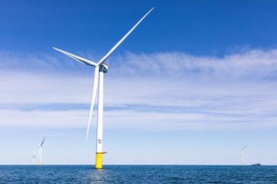
Vineyard Wind 1 is the first commercial-scale offshore wind energy project in the United States that is being developed by Vineyard Wind, an offshore wind development company 50% owned by Copenhagen Infrastructure Partners (CIP) and 50% owned by Avangrid Renewables.
Vineyard Wind 1 will consist of an array of 62 wind turbines spaced 1 nautical mile apart on an east-west and north-south orientation. The turbines are General Electric Halide-X turbines, each capable of generating 13 megawatts (MW) of electricity. Electricity generated by the turbines will be collected by an offshore substation prior to being transmitted to shore. Vineyard Wind 1 is estimated to generate 800 MW of electricity annually and power over 400,000 homes, an equivalent of removing 325,000 vehicles from roadways.
Two submarine cables will be installed along a carefully sited route from the offshore substation to the landing point onshore at Covell’s Beach in Barnstable. Submarine cables are buried up to six feet below the seafloor using a jetplow. The route was selected after extensive geological surveys of the area to avoid sensitive habitats. The onshore cables will be buried beneath public roadways in Barnstable.
From the onshore cable landing site, the cables will be installed underground along public roads to an onshore substation in the village of Hyannis. The Vineyard Wind 1 onshore substation will be adjacent to an existing Eversource substation.
Location
Vineyard Wind 1 is located in federal wind energy area OCS-A-0501, 15 miles south of Martha’s Vineyard and Nantucket, and 35 miles from mainland Massachusetts. The location was determined through a multi-year, intergovernmental task force process, which carefully considered scientific data and public input. Two submarine cables were installed along a carefully sited route from the offshore substation to the landing point onshore at Covell’s Beach in Barnstable. The route was selected after extensive geological surveys of the area to avoid sensitive habitats.
Project Timeline
- 2026, March 13: Construction complete
- 2026, Jan 27: U.S. District Court for the District of Massachusetts issued decision to allow project to resume construction
- 2025, Dec 22: Stop order issued by BOEM
- 2025, May: The U.S. Supreme Court denied petitions from fishing industry lobbying group, Responsible Offshore Development Alliance (RODA) challenging the Vineyard Wind project
- 2025, January: BOEM approves COP revisions, and BSEE lifts its suspension order
- 2024, December: Revised COB submitted for review to remove blades from 22 turbines
- 2024, July: Blade failure resulting in the release of blade debris into the environment
- 2023, June: Offshore installation of turbines expected to begin
- 2022, October–November: Offshore cable installation
- 2021, May: BOEM releases Record of Decision (ROD). Onshore site preparation begins in Barnstable
- 2021, March: BOEM releases Final Environmental Impact Statement (FEIS)
- 2020, June: BOEM completes cumulative impact review and issues Supplement to Draft EIS
- 2020, Spring: State, regional, and local permitting completed
- 2019, May: State board EFSB approves Vineyard Wind 1 transmission
- 2019, February: Massachusetts Environmental Policy Act (MEPA) issues certification of Draft EIS
- 2018, December: Vineyard Wind submits FEIS to MEPA. BOEM issues Draft EIS. Vineyard Wind obtains second lease area, OCS-A-0522.
- 2018, April: Vineyard Wind submits plans for state review, initializing environmental review
- 2018, March: BOEM holds public meetings in advance of preparing an EIS
- 2017, December: Vineyard Wind 1 submits state and federal plans for Vineyard Wind 1 in lease area OCS-A-0501, including Construction and Operations Plan (COP) and transmission plans
- 2015, January: Department of Interior holds public auction for lease area OCS-A-0501, which Vineyard Wind obtains
- 2010-2014: Federal siting review for development of offshore wind energy on the outer continental shelf off the coast of Massachusetts and Rhode Island
Licensing Information
At the federal level, the lead permitting agency, the Bureau of Ocean Energy Management (BOEM), awarded the lease for Vineyard Wind in 2015 and in 2021, after the state, regional, and local permitting was completed issued the Final Environmental Impact Statement and Record of Decision. Several state and local authorities were involved in the project. At the state level, the Energy Facilities Siting Board approved the transmission cables and connection to the grid in Barnstable and the Massachusetts Environmental Policy Act Office issues the certification of its final Environmental Impact Report. Regionally, the Cape Cod and Martha’s Vineyard Commissions which reviewed and approved the Development of Regional Impact. Locally, the Towns of Barnstable and Edgartown which reviewed the onshore transmission and grid interconnection infrastructure plan to ensure compliance with the state’s Wetlands Protection Act.
Key Environmental Issues
- 2025, April: ACK for Whales filed a petition with the Interior Department and BOEM, asking the agencies to revoke the revised construction and operations permit they issued in January to allow the project to resume installation after the blade failure. The permit is required for Vineyard Wind to install and operate its project.
- 2025, March: ACK for Whales filed a petition with the U.S. Environmental Protection Agency, requesting the agency rescind the Clean Air Act permit it granted to Vineyard Wind to construct and operate its wind farm.
- 2025, March: Responsible Offshore Development Alliance (RODA) petitioned the U.S. Supreme Court to take their case and overturn the lower court’s rulings, but the Supreme Court rejected their petitions.
- 2025, February: The same turbine that broke in 2024 (A38) was hit by lightning. Aerial and vessel based investigations indicated no debris resulting from the lightening strike.
- 2024, July: One of the blades on a turbine (A38) in the southernmost end of the lease area broke and a large chunk of the blade fell into the water prompting an investigation by the Bureau of Safety and Environmental Enforcement (BSEE).
- 2019, January: Vineyard Wind 1 and the Natural Resources Defense Council, the National Wildlife Federation, and Conservation Law Foundation entered into a landmark agreement to protect critically endangered North Atlantic right whales. The agreement calls for restricting vessel speeds, limiting construction noise, work-stop measures, and no construction during migration season.
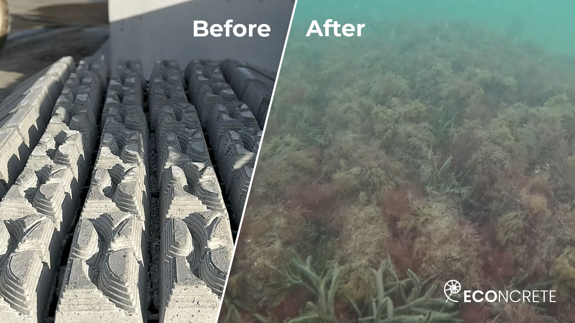
To comply with regulatory environmental requirements, Vineyard Wind used ECOncrete mattresses to provide cable protection and stabilization. The mattresses incorporate a bio-enhancing concrete admixture, surface complexity, and a Nature Inclusive Design (NID) aimed to support marine biodiversity. This creates a range of habitats that promote the settlement and growth of marine flora and fauna; increase species richness, which supports fish populations, contributes to local fisheries, and enhances the surrounding marine food web; and help reduce the dominance of invasive species. Read more about the deployment here. See a before and after photo and a video of an underwater survey carried out one year after the installation of ECOncrete’s marine mattress shows promising results.