Description
SouthCoast Wind, formerly known as Mayflower Wind, is a large-scale offshore wind energy project that is being developed approximately 30 miles south of Martha’s Vineyard and 20 miles south of Nantucket. Originally launched as a joint venture between Shell New Energies and Ocean Winds, the project is now led by Ocean Winds. The project aims to deliver up to 2,400 MW, enough to power over one million homes across New England.
In 2025, Ocean Winds announced that SouthCoast Wind is facing construction delays of up to four years, pushing construction from 2025 to 2029 or 2030.
Location
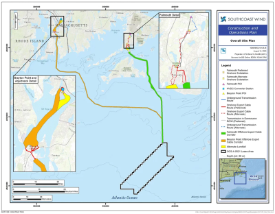
The SouthCoast Wind lease area is located over 48 km south of Martha’s Vineyard, 32 km south of Nantucket, and over 96 km south of Rhode Island. The project will occupy the full 199-square mile (over 127,000 acre) lease area. Dual grid connection points are being pursued (1,200 MW to Brayton Point/Somerset and 1,200 MW to Falmouth) to maximize the potential of the offshore lease area’s generation capacity. There is 2.7 miles of submarine cable routing from the lease area to Brayton Point.
Project Timeline
- January 2025: Ocean Winds delayed construction until 2029 or 2030
- January 2025: BOEM approved SouthCoast Wind’s Construction and Operations Plan
- March 2024: Shell New Energies US LLC sold its 50% equity share in SouthCoast Wind to Ocean Winds
- December 2024: Department of the Interior announced the approval of SouthCoast Wind
- April 2023: BOEM announced comment period extension for the Draft Environmental Impact Statement
- February 2023: BOEM Announced the Availability of the Draft Environmental Impact Statement
- May 2020: Site Assessment Plan approved
- December 2018: SouthCoast Wind (then Mayflower Wind) wins lease area OCS‑A 0521 in BOEM auction
Licensing Information
Ocean Winds is developing the SouthCoast Wind in federal waters leased from the Bureau of Ocean Energy Management (BOEM). Key federal agencies involved in the permitting and licensing process include BOEM, the U.S. Environmental Protection Agency (EPA), the National Oceanic and Atmospheric Administration (NOAA), and the U.S. Army Corps of Engineers, among others. The project required a number of approvals, notably the Construction and Operations Plan (COP), which underwent extensive environmental review culminating in a Final Environmental Impact Statement (EIS) and a Record of Decision (ROD) issued by BOEM in December 2024. Additionally, the project secured an Outer Continental Shelf (OCS) Clean Air Act permit from the EPA in January 2025. The permitting and consenting process spanned nearly four years, beginning with the initial COP submission in early 2021 and concluding with final approvals in early 2025, encompassing stakeholder engagement, public comment periods, and multiple rounds of technical and environmental review.
View updates for SouthCoast Wind on the FAST41 Permitting Dashboard.
Key Environmental Issues
SouthCoast Wind faces several key environmental challenges due to its location in a biologically rich offshore area. One of the primary concerns is the potential impact on the critically endangered North Atlantic right whale, whose migration routes pass through the project site. To mitigate risks, Ocean Winds plans to implement seasonal construction restrictions and vessel speed limits during periods when whales are likely to be present. The project also includes monitoring protocols for protected marine species and measures to minimize impacts on benthic habitats during submarine cable installation, such as pre- and post-construction seafloor surveys and the use of horizontal directional drilling at cable landfall locations to reduce coastal disturbance.
SouthCoast Wind is supporting research on fisheries in and around its lease area through several partnerships. The New England Aquarium (NEAq) Anderson Cabot Center of Ocean Life’s (ACC) Fisheries Science and Emerging Technologies (FSET) program will monitor highly migratory fish species using acoustic tagging. The University of Massachusetts, Dartmouth School for Marine Science and Technology (SMAST) will conduct fisheries monitoring and impact assessment surveys. INSPIRE Environmental will develop and conduct a fisheries monitoring plan to establish baseline of fisheries resources and track impacts. SouthCoast Wind was a founding Board member of the Responsible Offshore Science Alliance (ROSA) and is also working with Northeastern Regional Association of Coastal Ocean Observing Systems (NERACOOS) to share real-time wind and ocean current observations from the FLiDAR buoy in its lease area. SouthCoast also included an acoustic receiver on the buoy to identify tagged cod moving across the area to Cox's Ledge.
Environmental Papers and Reports
- The presence, persistence, and movements of highly migratory pelagic fishes (HMS) in southern New England offshore wind lease areas from 2022-2023 determined by acoustic telemetry (Kneebone et al. 2025)
- Conditions of Construction and Operations Plan Approval Lease Number OCS-A 0521 (BOEM 2025)
- SouthCoast Wind Project Construction and Operations Plan Record of Decision (BOEM et al. 2024)
- SouthCoast Wind Project Final Environmental Impact Statement (BOEM Office of Renewable Energy Programs 2024)
- SouthCoast Wind Construction and Operations Plan (SouthCoast Wind Energy LLC 2024)
- Supplemental North Atlantic Right Whale Monitoring and Mitigation Plan for Pile Driving (SouthCoast Wind Energy LLC 2024)
- Fisheries Baseline Analysis for Rhode Island for the SouthCoast Wind Brayton Point Export Cable Route and Rhode Island GLDs (Kite-Powell et al. 2023)
- Megafauna Aerial Surveys in the Wind Energy Areas of Southern New England with Emphasis on Large Whales: Final Report Campaign 7, 2022 (O'Brien et al. 2023)
- SouthCoast Wind Draft Environmental Impact Statement (BOEM Office of Renewable Energy Programs 2023)
- Mayflower Wind Fugro Geophysical Survey 2021 IHA Final Protected Species Observer Report Final (Milne and RPS group 2022)
- Conditions of Site Assessment Plan Approval for Lease OCS-A 0521 (BOEM 2020)
- Site Assessment Plan Mayflower (SouthCoast) Wind Lease OCS-A0521 (ESS Group and Mayflower Wind Energy LLC 2019)
See SouthCoast Wind’s Permitting & Documents Page and BOEM’s Renewable Energy Page for additional data and information.
NOAA Fisheries has developed Offshore Wind Lease Reports that summarize previous fishing activity within each offshore wind lease area along the U.S. Atlantic Coast. View Descriptions of Selected Fishery Landings and Estimates of Vessel Revenue from Areas: A Planning-level Assessment and Descriptions of Selected Fishery Landings and Estimates of Recreational Party and Charter Vessel Revenue from Areas: A Planning-level Assessment for SouthCoast Wind (OCS-A-0521) here.
Environmental Monitoring: SouthCoast Wind
| Phase | Stressor & Receptor | Design and Methods | Results | Publications | Data |
|---|---|---|---|---|---|
| Baseline | Birds | Aerial Surveys, Boat-Based Surveys High-definition (HD) aerial imagery was collected from November 2019 through October 2020 at the project site. Surveys were conducted monthly and sampling effort was increased during the migratory period for terns and other species of concern. A series of geophysical and geotechnical (G&G) vessel surveys completed in the Lease Area between September and November 2019 included an onboard professional avian observer who recorded all birds observed during the surveys. | Complete Most species evaluated showed low to moderate exposure in the Lease Area, with no strong evidence of high seasonal use. For more information on specific species see report. See Appendix I1. | SouthCoast Wind Energy LLC 2024 | No data publicly available. |
| Baseline | Fish | Acoustic Telemetry Study This study collected baseline information on highly migratory species’ use of popular fishing grounds within the lease area and tested the performance of acoustic telemetry as a long-term monitoring technique. Focus was placed on bluefin tuna, blue shark, shortfin mako, and yellowfin tuna as these species composed the largest number of individuals. | Complete Seasonal distributions of highly migratory species across both 2022 and 2023 corroborate the anticipated habitation of the area in warmer months (June to October) and the gradual departure of animals with progression towards cooler months (November to January). Numerous tagged individuals returned to the area and were detected in years subsequent to tagging. Further monitoring will continue and data from the acoustic monitoring performed in 2024 will be compiled, analyzed and synthesized into a forthcoming report. | Kneebone et al. 2025 | No data publicly available. |
| Baseline | Marine Mammals, Reptiles | Aerial Surveys During the reporting period (February 2022 to August 2022), four types of aerial surveys were conducted in the main study area: general, directed, and condensed surveys. One calibration survey was conducted in Massachusetts Bay, MA. | Complete A total of 4,203 detections of marine fauna (60%) and human activity (40%) were observed in the study area during all aerial surveys. Of these detections, 61% (n = 2,557) were observer detections and 39% (n = 1,646) were camera detections. Seasonal density and abundance estimates were calculated for various species from these findings. | O'Brien et al. 2023 | |
| Baseline | Physical Environment | Benthic Surveys Surveys were conducted in Spring and Summer of 2020 and included sediment grab samples, real-time video and sediment profile imaging. | Complete The benthic substrate in the Southern ECC and Lease Area is mostly fine, sandy material with minimal complex habitats observed. The area is dominated by surface-dwelling epifauna and soft sediment fauna, with any impacts on benthic species expected to be low, localized, and short-term. See Appendix M | SouthCoast Wind Energy LLC 2024 | No data publicly available. |
| Baseline, Construction, Operations | Ecosystem Processes, Physical Environment | Metocean Buoy Observations SouthCoast Wind deployed a metocean buoy in the Lease Area from January 2020 to January 2022 to collect wind, weather, and oceanographic data. The buoy included a floating LiDAR system for vertical wind profiling and additional sensors to measure waves, currents, temperature, salinity, and tides, providing a comprehensive, long-term dataset to support wind resource and site assessments. | Complete Results showed that the turbine structures and wakes are unlikely to produce enough mixing energy to break down the thermocline or alter copepod distribution at meaningful scales, suggesting minimal impact on important species like the right whale foraging habitat. See Appendix F4 | SouthCoast Wind Energy LLC 2024 | No data publicly available. |
| Construction | Noise, Vessel Strike Marine Mammals |
Additional Visual Monitoring for the North Atlantic Right Whale (NARW) Specific monitoring tools and plans will be developed as a part of the Marine Mammal Protection Act Incidental Take Authorization process, but may include the use of advanced infrared systems, real-time PAM, autonomous underwater vehicles, autonomous aerial vehicles, or other advanced technologies. | Planned See Volume II: Appendices A-H | BOEM Office of Renewable Energy Programs 2023 | No data publicly available. |
| Construction, Operations | Noise, Vessel Strike Marine Mammals, Reptiles |
Visual and Passive Acoustic Monitoring Marine mammal and sea turtle monitoring during pile driving will be conducted by qualified Protected Species Observers (PSOs) and Acoustic PSOs (APSOs). PSOs will perform visual monitoring from vessels while APSOs will operate real-time Passive Acoustic Monitoring (PAM) systems to detect vocalizing marine mammals. Sound Source Verification (SSV) will also be conducted to validate underwater noise levels and inform mitigation thresholds. | Planned See Appendix O. | SouthCoast Wind Energy LLC 2024 | No data publicly available. |
| Construction, Operations, Decommissioning | Fish, Reptiles | Sea Turtle/Atlantic Sturgeon Identification and Data Collection Any sea turtles or Atlantic sturgeon caught or retrieved in any fisheries survey gear will first be identified to species or species group. Each ESA-listed species caught or retrieved must then be documented using appropriate equipment and data collection forms. Biological data collection, sample collection, and tagging activities must be conducted. | Planned See Appendix G. | BOEM Office of Renewable Energy Programs 2024 | No data publicly available. |