Description
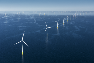
Ørsted’s Anholt Offshore Wind Farm has a nameplate capacity of 400 MW, which made it the world’s largest wind farm at the time of construction and the largest wind farm in Demark from 2013 to 2019. It took a total of three years from the award of the contract in 2010 until the entire wind farm was commissioned in 2013, with construction lasting only 18 months. Anholt is composed of 111 SWT 3.6-120 turbines spaced between 500 and 800 m apart and has the capacity to power 400,000 homes. The offshore wind farm is approximately 20 km long and 5 km wide.
Location
Anholt Offshore Wind Farm is located between Djursland and the island of Anholt in the Kattegat Sea, roughly 21 km from shore. The onshore service organisation is in Grenå, 60 km east of Aarhus in Jutland.
Project Timeline
- 2023: Cable Framework Agreement expired
- 8 April 2022: A rotor and three blades fell into the sea
- 4 September 2013: Anholt inaugurated and commissioned
- June 2013: Anholt achieved full power
- May 19, 2013: The last of the 111 turbines was erected
- October 2012: First electricity
- September 2012: Erection of wind turbines commenced
- June 2012: Cable installation commenced
- March 2012: Transformer platform work commenced
- January 13, 2012: Construction officially started
- December 31, 2011: Heavy lift vessel, Svanen, placed the first foundation monopile
- Fall 2011: Shore landing cable work commenced
- July 2010: Geological surveys commenced
- July 2, 2010: Concession granted to Ørsted
- April 2010: DEA receive tender
- April 2009: DEA release tender specifications
- February 2008: Political agreement of the establishment of a 400 MW wind farm
Licensing Information
DONG Energy (now Ørsted) first submitted a binding tender to the Danish Energy Agency for the concession to build a 400 MW offshore wind farm off Anholt in the Kattegat in April 2010. The Danish Energy Agency awarded DONG Energy the concession in June 2010. PensionDanmark and PKA signed an agreement with DONG Energy in March 2011 to acquire 50% of the Anholt offshore wind farm for ~DKK 6 billion. DONG Energy also signed a 15-year contract with PensionDanmark and PKA on operation and planned maintenance of the farm.
Key Environmental Issues
Early literature reviews and surveys of benthic communities, bats, birds, and marine mammals during targeted field campaigns during winter and spring 2009 were used for sensitivity analysis and to predict changes during construction, operation, and decommissioning and develop mitigation plans.
In 2022, Ørsted and WWF Denmark installed 3D-printed reef structures on the seabed between the wind turbines at Anholt. The 25 boulder reefs, which are the first of their kind in Danish waters, weigh up to half a ton and are roughly 1 m3 in size but vary in shape to best imitate natural habitats. In 2024, the reefs hosted a variety of fish species, such as goldsinny wrasse, marine invertebrates, such as tunicates and starfish, and crustaceans. Pictures from the deployment are available here and a video about the reefs is available here.
Ørsted also launched a trial at Anholt in 2022 with DWV, a transport and logistics leader in Denmark, to assess the role cargo drones can potentially play in sustainable logistics for offshore wind farms. Pictures and video from the test flights are available here.
In 2023, as part of the ULTFARMS project, researchers from the Technical University of Denmark began putting lines in the water around the Anholt Offshore Wind Farm turbines and attached seedlings to cultivate three different types of seaweed that can be used for human consumption. Cultivation of seaweed was scheduled to begin in 2024. Mussel farming began in 2024.
- Sensitivity mapping of relative risks to bats from Danish offshore wind energy (Brinkløv et al. 2025)
- Anholt wind farm’s impact on benthic biodiversity at turbine and farm level (Dahl et al., 2025)
- Environmental mapping and screening of the offshore wind potential in Denmark: Sensitivity mapping: Benthic habitats and associated biological communities (Göke et al., 2025)
- Environmental Mapping and Screening of the Offshore Wind Potential in Denmark: Sensitivity mapping: Wind (Hahmann et al., 2025)
- Ocean currents and water mass properties inside the Anholt offshore wind farm (Mohn et al., 2025)
- Investigating Avian habitat modification and behavioral dynamics in active wind farm environments (Salkanovic, et al., 2024)
- Anholt Offshore Windfarm - Stabilisation of Cable Protection Systems and Cables at Scour Protected Monopile Locations and the Offshore Substation (Grindlay and Fischer, 2023)
- Anholt Offshore Wind Farm Project Description (Energinet.dk, 2010)
- Anholt Offshore Wind Farm Tourism and Recreational Activities (Energinet.dk, 2009)
- Anholt Offshore Wind Farm Air Emissions (Energinet.dk, 2009)
- Anholt Offshore Wind Farm Marine Geophysical Investigations (Leth, et al., 2009)
- Anholt Offshore Wind Farm Marine Mammals (Energinet.dk, 2009)
- Anholt Offshore Wind Farm Birds (Energinet.dk, 2009)
- Anholt Offshore Wind Farm Benthic Habitats (Energinet.dk, 2009)
- Anholt Offshore Wind Farm Method for impact assessment (Energinet.dk, 2009)
Ørsted offers access to operational data from Anholt offshore wind farm to support universities and research institutions conducting research projects without commercial purposes, including:
- 2 years of 10-minute SCADA data (nacelle wind speed, electrical power, rotor speed, yaw position and pitch angle) for all turbines together with on-site 10 min. statistics from wave buoy data and ground-based LIDAR data.
- 10-minute statistics for offshore wind measurements including offshore wind speed and wind direction data from LIDAR data.
Environmental Monitoring: Anholt Offshore Wind Farm
| Phase | Stressor & Receptor | Design and Methods | Results | Publications | Data |
|---|---|---|---|---|---|
| Baseline | Marine Mammals | Satellite telemetry, acoustic data, aerial line transects and counts on haul-out sites Habitat suitability analysis were completed for harbor porpoise, harbor seal, and grey seal. | Complete Telemetry data indicated the southern-central part of the region and area north of Anholt is used more intensively by porpoise than shallower areas with lower salinity and more flat terrain. Grey seals were only observed as individuals and small groups at the shores at Anholt. Harbor seals had high suitability north-south off the Totten colony, and not the Anholt OWF, with an area of higher suitability east of the Project Area. Models suggest that masking of communication by harbor porpoise might occur at distances of 20 km or more but not masking of echolocation. | Rambøll Group and DHI A/S 2009 | No data publicly available |
| Baseline | Habitat Change Physical Environment |
Geophysical Surveys Geophysical surveys were performed in April-May 2009 using multibeam systems, a magnetometer, sound velocity profiling, sonar, vibrocoring, and ground truthing in the area of the cable corridors connecting the Anholt wind farm area in Kattegat between Grena and the island Anholt with Djursland. | Complete Thematic maps were created. The seabed sediment map shows the generally coarser seabed types along the northern corridor. Bathymetric mapping based on multibeam data shows the latter corridors in general is level apart from the coastal zone. The distribution of the Holocene deposits indicates a thin cover layer of a few meters thickness. | Leth et al. 2009 | No data publicly available |
| Operations | Habitat Change Physical Environment |
Benthic Biodiversity Assessment Field work was conducted between 22 and 24 May 2023 using the AU research vessel, equipped with a dynamic position system that allowed for precise data sampling even close to the turbines. Soft bottom fauna samples were taken during April-May 2023. Turbines I-04, F-05, and F-06 were selected as sampling sites for the study of near-field effects. ROV, core sampler, and pots were used. Video footage was collected around the selected turbines. Infauna sampling was also conducted. Lab and statistical analysis was conducted on data gathered from the study. | Complete Significant changes were observed in total abundance, biodiversity, species richness and calculated environmental quality indices, but these were coupled to general changes in the Kattegat area rather than to the establishment of the wind farm. | Dahl et al. 2025 | No data publicly available |